
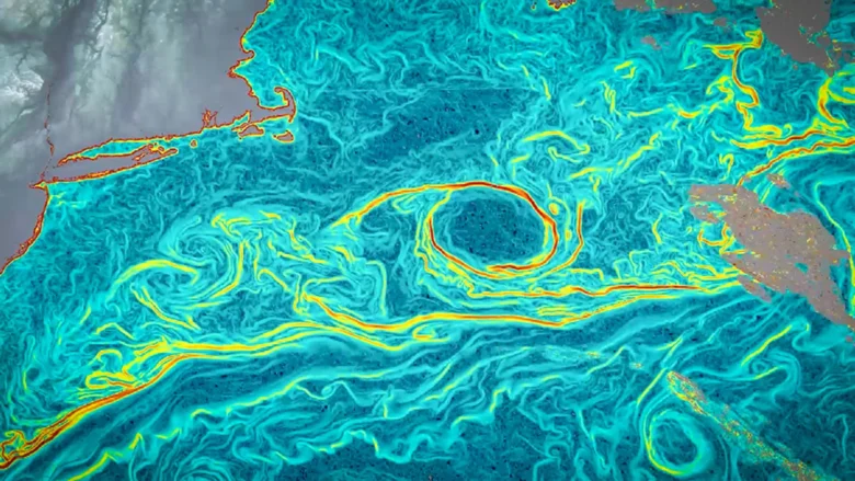
Scientists have introduced a new way to track ocean surface currents across vast areas with far greater detail than before. The technique, known as GOFLOW (Geostationary Ocean Flow), uses deep learning to analyze thermal images captured by weather satellites that are already in orbit. Because it relies on existing satellites, the method delivers a major advance in ocean monitoring without requiring new equipment in space.
The research was led by Luc Lenain of UC San Diego’s Scripps Institution of Oceanography and Kaushik Srinivasan, a Scripps alumnus now at UCLA. Their findings were published in Nature Geoscience. Co-authors Roy Barkan of Tel Aviv University and Nick Pizzo of the University of Rhode Island also trained at Scripps. Funding came from the Office of Naval Research, NASA and the European Research Council.
Why Ocean Currents Matter for Climate and Life
Ocean currents are essential to how the planet works. They move heat around the globe, transfer carbon between the atmosphere and the deep ocean, and circulate nutrients that support marine ecosystems. They also play a critical role in real-world situations such as search and rescue efforts and tracking oil spills.
Despite their importance, accurately measuring currents across large regions has been difficult. Some satellites estimate currents indirectly by observing changes in sea surface height, but they usually revisit the same area only about once every 10 days — far too slow to capture currents that can form and fade within hours. Ships and coastal radar can detect rapid changes, but only over limited areas.
The Missing Link in Ocean Mixing
This limitation has left scientists with a major blind spot at the scales where vertical mixing occurs. Vertical mixing happens when surface waters move downward or deeper waters rise, and it is driven by features that can be smaller than 10 kilometers (six miles) and change quickly.
Understanding this process is crucial. It brings nutrients from the deep ocean up to the surface, supporting marine life, and carries carbon dioxide downward where it can be stored long-term. Without detailed observations, much of this activity has remained difficult to measure directly.
Turning Satellite Images Into Ocean Flow Maps
The idea for GOFLOW began in 2023 when Lenain examined thermal images of the North Atlantic from the GOES-East satellite, which is typically used for weather monitoring. These images are captured as often as every five minutes and show clouds as well as patterns of warm and cool water moving across the ocean surface.
Lenain noticed that major currents such as the Gulf Stream were visible in these temperature patterns. This observation led to the idea of converting those patterns into a new way to measure ocean currents.
How AI Tracks Ocean Currents
To make this possible, the research team trained a neural network to recognize how temperature patterns on the ocean surface shift and change shape under the influence of currents. The system learned from detailed computer simulations of ocean circulation, which linked specific temperature patterns to known water velocities.
Once trained, the model analyzed sequences of satellite images and tracked how these patterns moved over time. From this motion, it could determine the underlying currents responsible for the changes.
“Weather satellites have been observing the ocean surface for years,” said Lenain. “The breakthrough was learning how to turn that time-lapse into hourly maps of currents by tracking how temperature patterns bend, stretch and move from one hour to the next.”
Testing Accuracy Against Real-World Data
The researchers evaluated GOFLOW by comparing its results to direct measurements collected by ships in the Gulf Stream region during 2023, as well as traditional satellite methods based on ocean topography. The results closely matched both sources.
However, GOFLOW provided much sharper detail, especially for small, fast-moving features such as eddies and boundary layers. Earlier methods often smoothed these features into broad averages. With the improved resolution, the team was able to detect key statistical patterns of small, intense currents that drive vertical mixing. Until now, these patterns had mainly been seen in simulations rather than direct observations.
“This opens a range of exciting possibilities in physical oceanography that, until now, were largely accessible only through simulations,” said Lenain. “Using GOFLOW, we can now measure key signatures of these small, intense currents using real observations rather than relying almost entirely on simulations. This opens the door to testing long-standing ideas about how the ocean takes up heat and carbon.”
No New Satellites Required
Because GOFLOW works with data from existing geostationary satellites, it does not require launching new instruments into space. Over time, the method could be integrated into weather forecasting systems and climate models. By capturing rapidly changing currents, it may improve predictions related to air-sea interactions, marine debris movement and ecosystem dynamics.
Challenges and Future Expansion
Cloud cover remains a limitation, since clouds block the thermal images that GOFLOW depends on. The research team plans to combine additional satellite data sources to fill in these gaps and achieve more consistent coverage.
Work is already underway to expand the method to a global scale. The team has also made its data products and code publicly available, which could help other scientists build on the approach and explore new applications.